Saturday 28 May 2016

MIRPUR

MIRPUR


Mirpur (Urdu, Punjabi: مِيرپُور or more commonly known as New Mirpur City) is the capital of Mirpur district and is one of the largest cities of Azad Kashmir. The city itself has gone through a process of modernization, while most of the surrounding area remains agricultural. Mirpur is known for its grand buildings and large bungalow-houses primarily funded through its ex-patcommunity, which comes mainly from the United Kingdom, Europe, Hong Kong, Middle East and North America. The main crop cultivated during summer is millet and pulses. However, there are places where other crops such as wheat, maize and vegetables are also grown. The produce of quality rice from the paddy fields of khari Sharif between Upper Jhelum Canal and Jhelum river are very famous and popular for its aroma and taste. The production of electricity, through Mangla Dam makes this district somewhat unique in the entire region which provides energy needs for Azad Jammu and Kashmir and Northern Punjab province.

A significant portion of the population from the district migrated to the United Kingdom in mid to late 1950s and in early 1960s – mostly to West Yorkshire, East Midlands, West Midlands, Luton, Peterborough, Derby and East London. 70% of the British Pakistanis are Mirpuris. For this reason Mirpur is sometimes known as "Little England". Many products from the UK are found in this city. Many shops in the city accept the Pound sterling.

 Chowk Shaheedan

HISTORY


The area that is now Mirpur has always been a crossroad for major invasions of the South Asia and has formed part of various empires over time including the role of an outlying region of the conquests of Alexander the Great, the Kingdom of Gandhara, the Mauryan empire, the Kushan empire, the Sultanate of Ghazni, the Delhi Sultanate and the Mughal empire amongst others.

The Mirpur city itself was founded in around 1642 AD or 1052 AH by the Ghakhar chief Miran Shah Ghazi. The Imperial Gazetteer of India Provincial Series Kashmir and Jammu (1909) provides this information about Mirpur history as "it is said to have been founded by Miran Shah Ghazi and Sultan Fateh Khan". An alternate view is that the city was founded by Mira Shah Gazi and Gosain Bodhpuri, both regarded as saints. The word 'Mir' was taken from the name of the former while 'Pur’ from the latter.
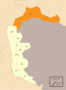

MIRPUR MAP


In 997 CE, Sultan Mahmud Ghaznavi, took over the Ghaznavid dynasty empire established by his father, Sultan Sebuktegin, In 1005 he conquered the Shahis in Kabul in 1005. The Delhi Sultanate and later Mughal Empire ruled the region. The Punjab region became predominantly Muslim due to missionary Sufi saints whose dargahs dot it's landscape

The area that is now Mirpur has been historically associated with Pothohar. Though modern demarcation of Potohar devised by British excludes Mirpur by using Jhelum river as the eastern boundary. By the end of the 18th century, Gakhar power in Pothohar had declined. Mirpur had become part of Chibb ruled state of Khari Khariyali with capital at Mangla Fort. With the rise of Sikh power in Punjab, Maharaja Ranjit Singh established his supremacy and set his eyes on the Chibh states of Bhimber and Khari Khariyali. In 1810, a force was sent against Raja Sultan Khan of Bhimber and was met with fierce resistance. However, in 1812 another Sikh army under prince Kharak Singh defeated SultanKhan and the Bhimber state was annexed as Jagir of Kharak Singh. Around the same time, Ranjit Singh acquired Gujrat and invaded Khari Khariyali ruled by Raja Umar Khan. Raja Umar Khan made peace with Ranjit Singh. But before a settlement could be made, he died and the state and Mirpur became part of Ranjit Singh's territories.

In 1816, Ranjit Singh annexed Jammu state and in 1820 awarded Jammu to his commander Gulab Singh who hailed from Jammu and was under the service of Ranjit Singh for the past eight years. Between 1831–39 Ranjit Singh bestowed on Gulab Singh the royalty of the salt mines in northern Punjab, and the northern Punjab towns including Bhera,Jhelum, Rohtas, Mirpur and Gujrat. Gulab Singh kept on expanding his kingdom and in 1840 Baltistan was made subject to Jammu and Gilgit fell to a Sikh force from Kashmir in 1842. The state of Kashmir was annexed by Ranjit Singh in 1819. However the rebellion in Hazara in the beginning of 1846, compelled the country to be transferred to Raja Gulab Singh of Jammu as well. As an aftermath of the First Anglo-Sikh War and the Treaty of Lahore, The Treaty of Amritsar was signed between the British Government and Raja Gulab Singh of Jammu on March 16, 1846. The British Government sold Kashmir to the Raja of Jammu for 75 lakhs Nanak Shahi Rupees. This treaty transferred him all the hill states between Ravi and Indus. The transfer included Kashmir, Hazara and the southern hill states (including former Khari Khariyali Thus sealing the fate of Mirpur with the new state of Jammu and Kashmir.

KOTLI


Kotli

Kotli (Urdu: کوٹلی‎) or Cotly, as known in Britain, is the chief town of Kotli District, in the Azad Kashmir. Kotli is linked withMirpur by two metalled roads, one via Rajdhani, (90 km) and the other via Charhoi. It is also directly linked with Rawalakotvia Trarkhal (82 km) and a double road which links Kotli with the rest of Pakistan via Sehnsa, another major town in Azad Kashmir. Kotli is roughly a three hours drive from Islamabad and Rawalpindi, at a distance of 117 km via Sehnsa.


History


As stated in History of the Punjab Hill States by J.Hutchinson and J.P. Vogel: "Kotli was founded about the fifteenth century by a branch of the royal family of Raja Mangar Pal . Kotli and Poonch remained independent until subdued by Ranjit Singh in 1815 and 1819 respectively."

The royal family of Hutchinson and Vogel are referring to is the family of Raja Mangar Pal.[citation needed] Before its name was Kohtali mean (under mountain) after that people changed its name to Kotli.

Indo-Pakistan War of 1947–48


In November 1947, the Indian Army reached Kotli and evacuated the garrisons of the town. The Pakistani Army along with the local population and aided by the tribesmen of the North West Frontier Province arrived and counter-attacked, forcing the Indian Army to abandon it. Kotli has been under Pakistani administration since.

Modern Kotli


The main distinction to the city is Jamay Masjid Al-Firdous Gulhar. It is the religious centre of excellence and it centralizes more than seven hundred mosques all over the world, the most of which are in Azad Kashmir. Hazrat Khawaja Muhammad Sadiq (Rahmatullah Alaihee) laid foundation of this system and now his son Mr. Haafiz Muhammad Zahid Sultani is supervising the system efficiently.Today Kotli is a winter town.[clarification needed] Notable places in Kotli to visit are sarda point, Tinda Rest-House, near river gori park, roli hills, butt fire and Peer Lasura (Nakyal). Today kotli is shaping itself in almost every field of life.Some notable places are Gulhar colony, Khuiratta, Chowki Tinda, Kurti, Roli, Brali and Dhamol. The town has become a vision of three-storey mansions that have taken over the once-barren roads between the outer ring villages and the ever-expanding city sitting on the brim of the Poonch River. The most famous and notable buildings are the three Khan-Wali fortresses, Jame Masjid Ghosia Balyah and Tehsil Guest House (Some Great people used to stay there since it was built by Dogra rulers).

The mass emigration that took over the country in the 1960s has now created a steady boom of summer holiday makers from Britain and beyond who seek to reconnect their European-born children to the old country. Kotli has international links throughout Western Europe and North America. Like many Azad Kashmiris (Poonch valley — a region found in the Jammupart of Jammu and Kashmir) living in the fringes of the Mangla Dam in Mirpur, emigration fever took hold of the surrounding country from the mid 1950s onwards.

Kotli has ties with many European cities such as Amsterdam, Hamburg and especially the larger industrial cities of northern and central England. Many Kotli city residents have ties to British nationals in the city of Manchester, Sheffield, Leeds, Bradford, Luton, Bedford, Watford and Birmingham. Kotli is also known as the city of mosques due to the fact that there are more than three hundred mosques in Kotli.

Faizan Rehman is currently the territory executive for Kotli district.

Communications

  • Three privately owned cable Television systems: Kashmir Cable Network Covering 90% area of Kotli City and Surroundings, Family Cable Network, and Medialink Cable Network, are available in Kotli, which transmit Pakistanin and international television programs.
  • A local FM radio station also broadcasts at FM 96.5.
  • Cell phone service is available through six private cell phone operators: Paktel, Mobilink, Ufone, Warid, Telenor and SCOM. PTCL Wireless is also available.

POONCH

Poonch district, Pakistan


Poonch
District
Poonch
Map of Azad Kashmir with Poonch highlighted
Map of Azad Kashmir with Poonch highlighted
Coordinates: 33.8540°N 73.7507°E
CountryPakistan
ProvinceJammu and Kashmir
HeadquartersRawalakot
Area
 • Total855 km2 (330 sq mi)
Population (1998)
 • Total459,000
 • Density548/km2 (1,420/sq mi)
Time zonePST (UTC+5)
Poonch (Urduضلع پونچھ ‎) is one of the eight districts of Azad Jammu and Kashmir. Poonch district borders Indian-administered Kashmir and is part of the greater dispute between India and Pakistan.
The capital of the district is Rawalakot with the Sudhan and Awan tribes being the dominant groups in the district. This region has produced numerous business, political and military leaders.

History

From the end of seventeenth century up to 1837 CE, Poonch was ruled by the Muslim Rajas of Loran in Tehsil Haveli. It then fell into the hands of Raja Faiztalab Khan of Rajouri to whom it was handed over by the Punjab Government. Poonch was included in the transfer of the hilly country to Maharaja Gulab Singh of Jammu and Kashmir in 1848. Before this transfer, Poonch was considered a district of Lahore. Maharaja Gulab Singh granted Chibal, Poonch and other areas to Jawahar Singh and Moiti Singh. The Raja of Poonch had to present to the Maharaja one horse with gold trappings. The Raja of Poonch was not to effect any administrative changes in the territory of Poonch without prior consultation with the Maharaja of Kashmir. A GOLDEN POINT≈ There is confusion among the people of Ponch that they are the son of sudhozai, it is wrong there generation is started from Sudho(A PASHTUN PERSON) not from Sudhozai(A TRIBE NAME) and there generation got the name of sudhozai. Sudho was not sudhozai The generation after him gave themsalve name of sudhozai them self

Separation of Poonch


Map of Poonch district
After independence in 1947, Pakistan and India fought a war over Kashmir. As a result of the war, Poonch was split between the two nations. Prior to the division of Poonch, the only high school in the district was in the city of Poonch; this city now forms the capital of Indian-controlled Poonch district.

Lohar Dynasty

The centre of Lohar dynasty was at Loharin which is now in Poonch district of the state Kashmir. Prominent Hindu kings of this dynasty have carved out a special place in the history of Kashmir.
This clan is famous in Kashmir history since it gave a whole dynasty which ruled for a long time called 'Lohar dynasty'. Their settlement is located in Pir Panjal Range. They were Vaishnavites and followers of Lord Vshnu of the Hindu pantheon of Gods. The Lohar fort is named after them. The famous queen Dida, married to Kshemagupta, was daughter of King Simha Raja of Lohar dynasty, who himself was married to a daughter of Shahi King Bhima Deva of Kabul. Lohar Kot was the name of the royal palace of the Lohar Dynasty. Alberuni (Abu Rayhan Biruni) refers to this castle Lohar Kot-as Loha Kot, and Mahmud Ghazni’s attack on Loha Kot was a dismal failure. Farishta tells that Muhmud failed because the fort “was remarkable on account of its height and strength. The Lohars had enough strength to defend the towering palace.
Lohar Dynasty ruled Kashmir for more than a century when Kshtriya rituals entered the Brahamnic cult. As is common with despotic rule, the whole period suffered from murders, suicides, corruption - material and moral - a record of which has been prepared by Kalhan Pandit who followed in the 12th century in the reign of Jayasinha. introduced was a slow but soothing stream aimed at raising up of moral and spiritual values and oneness of God. Lohar Dynasty was also defeated by great MUGAHL-E-AZAM Akbar in 1645A.D.Then AKBAR started rule over whole india.

Education

According to the Alif Ailaan Pakistan District Education Rankings 2015, Poonch is ranked 38 out of 148 districts in terms of education. For facilities and infrastructure, the district is ranked 140 out of 148. 

Transport

A bus across the LOC, the Poonch-Rawalakot bus has helped to re-establish ties across the border.

BAGH

Bagh District

Bagh District (Urduضلع باغ ‎) is one of the Ten districts of Azad Jammu and KashmirPakistan. The district, which had been part of Poonch District, was created in 1988.The district is bounded by Muzaffarabad District to the north, Poonch district to the south, and Poonch district of the Indian-administered Jammu and Kashmir to the east; it is bounded by the PunjabRawalpindi District and Abbottabad District of Pakistan's North-West Frontier Province to the west. The total area of the district is 1,368 square kilometers. Bagh District is linked to Muzaffarabad by two roads, one via Sudhan Gali (80 km) and the other throughKohala (97 km). It is situated 46 km from Rawalakot. The district's headquarters is located at Bagh. It is said that a bagh (garden) was set up by the landowner where the premises of the Forest Department are now located. As a result, the area that is now the district headquarters was named “Bagh”.
Ganga Choti , Bagh, Kashmir, Pakistan.jpg

History

There is an archaeological site located in Bagh called Bagh Fort.
District Bagh was created in 1988, when it was divided from Azad Jammu and Kashmir's Poonch District.

                        Administrative divisions

The district of Bagh is sub-divided into 2 tehsils:
  • Bagh Tehsil
  • Dhirkot Tehsil

Geography and climate

Panjal Mastan plains
Map of Bagh district
Topographically, the entire Bagh district is a mountainous area, generally sloping from northeast to south-west. The area falls in the lesser Himalayas zone. The main range in the district is Pir- Panjal. The Haji-Pir Pass is situated at the height of 3421 meters above sea level. The general elevation is between 1500 and 2500 meters above sea level. The mountains are generally covered with coniferous forests. Mahl Nala, in the Bagh sub-division, and Betar Nala, in the Haveli sub-division, are the two main streams. However, numerous other rivulets flow in the district.[6]
The climate of the district varies with altitude. The temperature generally remains between 2 °C to 40 °C. The main eastern part of the district is very cold in winter and moderate in summer. However, the lower valleys, the localities bordering Bagh at Kohala and its adjoining areas (Mongbajri and Ajra-Bagh) remain cold in winter and hot in summer. May, June and July are the hottest months. Maximum and minimum temperatures during the month of June are about 40 °C and 22 °C respectively. December, January and February are the coldest months. The maximum temperature in January is about 16 °C and minimum temperature is 3 °C respectively. Annual rainfall is about 1500 millimeters.

Demography

The total population of the district according to the 1998 census was 395,000, which is estimated to have increased to 434,000 in 2013, with an annual growth rate of 2%.

Economy and resources

There are minerals in Bagh such as deposits of slate, where there are proven deposits of 1 million tons which are suitable for building materials, specifically roofing and flooring.

Education

According to the Alif Ailaan Pakistan District Education Rankings 2015, Bagh is ranked 16 out of 148 districts in terms of education. For facilities and infrastructure, the district is ranked 108 out of 148.

2005 earthquake in relation to Bagh district

The city of Bagh, like other areas of the district, was heavily damaged in the 2005 Kashmir earthquake. Sixty percent of the buildings collapsed. Thousands of people died and many more found themselves homeless. In the aftermath of the earthquake, NATO came to the district to help with reconstruction and clearing. There was a report that an entire village was wiped out in the district. The U.S., through Pakistan, distributed vouchers so people could buy water and food.

 CRICKET STADIUM BAGH..

Thursday 19 May 2016

NEELUM

Neelam District


Neelam District (Also spelled Neelum District) (Urdu: ضلع نیلم ‎) is one of the ten districts of Azad Jammu and Kashmir, Pakistan.[1]Until recently it was part of Muzaffarabad District. It is bound by the Gilgit (Northern Areas) to the North, with Kupwara, Baramullaand Bandipore Districts of Indian-administered Kashmir in India to the South and Southeast, Muzaffarabad District to the Southwest and Mansehra District to the West. The district was badly affected by the 2005 Kashmir earthquake.


Administrative divisions

Neelam District is a part of Azad Kashmir which is part of the greater dispute between India and Pakistan. The district is administratively subdivided into two tehsils:
Athmuqam
Sharda

Languages

It is the northernmost district of Azad Kashmir. A variety of languages are spoken in the district. Kashmiri however, is the predominant language and is spoken mostly in the west, east, northeast and southwest towards the border with Muzzafarabad and NWFP (now Khyber Pakhtunkhwa). Shina and Kashmiri are the predominant languages spoken in the northeastern part of the district towards the border with Baramulla, Gurez, Bandipore, Astore District and Baltistan and also in the far north on the border with Diamer District. Pashto is also spoken in a few villages on the Line of Control with Kupwara. Other languages includeGojri and the Kundal Shahi Language which is an archaic form of Shina however, it is heavily influenced by Kashmiri and Hindko. The Kundal Shahi Language[3] is spoken in a village called Kundal Shahi near Athmuqam. The language is under tremendous threat. If the current situation of language loss continues unabated, it is estimated that the language will disappear in the near future
Ethnic groups[edit]
Neelaum District is the least populated of all the districts of Azad Kashmir. The ethnic groups living in Neelam District include Gujjars, Rajputs, Kashmiris, etc.

Geography

Map of Neelum district 

Neelam District is the largest district of Azad Kashmir by area. It is a valley extending approximately 200 kilometers along the Neelum River. Notable locations in the district include: Nausery, Leswa, Barian, Jura, Kundal Shai, Jagran, Salkhala, Shahkot, Athmuqam, Keran, Changan, Sharda, Kel, Taobat, and Halmat.

Education

According to the Alif Ailaan Pakistan District Education Rankings 2015, Neelam is ranked 33 out of 148 districts in terms of education. For facilities and infrastructure, the district is ranked 136 out of 148.